Take complete control of your cross bore program.
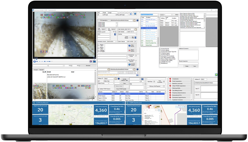
With MaxCommand, collect, integrate, and display millions of critical data points within a single, easy-to-understand interface. Manage every aspect of your program with uncompromised quality control and unlimited business intelligence.
understand the present | protect the future
Transparent insights and verified data
MaxCommand ushers in a new era in cross bore safety, providing a comprehensive digital suite that empowers 100% confidence in your program. This data-driven solution, equipped with high-accuracy GPS, advanced algorithms, and seamless GIS integration, offers real-time insights, verifiable metrics, and accurate decision-making, ensuring the highest standards of quality and transparency in cross bore safety management.
Digital cross bore program management
Bid farewell to uncertainties in cross bore safety management as MaxCommand heralds a new era. This comprehensive digital transformation suite ensures 100% confidence through cutting-edge data collection, analysis, and reporting.
MaxCommand is:
Traceable: Meticulous attention to detail is MaxCommand’s promise. Real-time collection of critical inspection data, coupled with sub-foot GPS coordinates, ensures nothing is overlooked.
Verifiable: Indisputable evidence backs key program metrics. MaxCommand seamlessly combines CCTV videos, GPS data, photographs, and field reports for undeniable verification.
Accurate: Uncertainty is a thing of the past. MaxCommand utilizes advanced algorithms and high-accuracy GPS data for precise measurements and defect detection, ensuring accurate decision-making.
Complete: MaxCommand acts as your program command center, capturing every detail for a comprehensive, easy-to-understand picture of your entire inspection program.
A data-driven approach for complete confidence.
MaxCommand, born from a commitment to digital verification, assembles the most advanced suite of technologies for cross bore safety. It provides transparent insights and verifiable data to help you reduce the risk of cross bores while protecting communities.
Technical features
- High-accuracy GPS data collection
- Comprehensive CCTV integration
- Advanced automation
- Seamless GIS integration
- Secure cloud storage
- Comprehensive data analytics
- User-friendly interface
- Configurable dashboards
Key benefits
- Real-time program insights
- Complete quality management at scale
- Understand the “big picture”
- Verifiably reduced risk
- Customizable reporting
- Increased efficiency
- Cost savings
- Peace of mind
- Unlimited interoperability
MaxCommand revolutionizes the way cross bore programs are managed, offering quick, informed decision-making through data-driven insights. Supported by indisputable evidence, it ensures your program reaches the highest standard of quality, promoting transparency with contractors.
Decades of data expertise
As an ESRI Silver Partner, our technology center is home to a dedicated team of over 70 full-time GIS professionals who bring a wealth of expertise in the development of client dashboards. These specialists have decades of experience working with client infrastructure data from across the country providing client information management, infrastructure program analytics, and value driven reporting.

2003
Two decades of experience
95M
Asset data points collected

70+
Data analysts, developers, and GIS specialists in our technology center

Esri
Silver Partner
Connect with a utility expert for a demo.
Submit your details below to learn more about our Advanced Field Services and Utility Solutions.